Favourite RPG Maps?

Best Selling RPGs - Available Now @ DriveThruRPG.com
I was thinking of something similar to that Nobby-W Nobby-W. Like a cube.
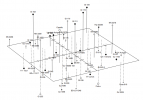
It is possible but it's hard to do that without it looking cluttered. The maps are based on nearby star data; the one at the bottom is a 10 parsec cube centred about the Sun. If I hadn't savagely culled it, there would be about 100 stars on the map.

You can do it, but it's not easy to do without the map looking messy and being difficult to interpret, and it definitely has limits as to how much you can fit on a single map.
 
Visualising 3D space effectively isn't that easy if you're just showing a map on paper. Beyond a fairly low level of complexity it's hard to stop the map from either (a) not showing the spatial relationships effectively or (b) being too cluttered.
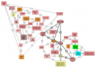
Personally I prefer a directed graph i.e. subway style maps if there is some type of "travel lane" or distance limit for interstellar travel. Keeping track of a 3D Model is fine for world building. But at the table and for your player's sanity, directed graphs are far more useful and just as accurate. I made this based off the second map above. Using a program called yEd,

1633962624311.jpeg
 
Personally I prefer a directed graph i.e. subway style maps if there is some type of "travel lane" or distance limit for interstellar travel. Keeping track of a 3D Model is fine for world building. But at the table and for your player's sanity, directed graphs are far more useful and just as accurate. I made this based off the second map above. Using a program called yEd,

View attachment 36662
Dot or graphviz is another way to make graphs like this. I remember using it to parts software relationships automatically.
 
Dot or graphviz is another way to make graphs like this. I remember using it to parts software relationships automatically.
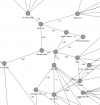
Yed's output is rather more legible than Graphviz. The same thing from Graphviz looks like this, although it also has routes into neighbouring sectors. Something that looked like what robertsconley robertsconley did would make a good supplement, if perhaps tarted up a bit. I think Yed also allows you to manually edit the graph.

Sol_Routes.png
 
Yed's output is rather more legible than Graphviz. The same thing from Graphviz looks like this, although it also has routes into neighbouring sectors. Something that looked like what robertsconley robertsconley did would make a good supplement, if perhaps tarted up a bit. I think Yed also allows you to manually edit the graph.

View attachment 36663
Two things. #1 theres a lot more going on in that Graphviz drawing which makes it look much busier and takes up more space than in the yEd pic. #2 I believe you can tweak Graphviz to look more like the yEd output if you want.
 
Personally I prefer a directed graph i.e. subway style maps if there is some type of "travel lane" or distance limit for interstellar travel. Keeping track of a 3D Model is fine for world building. But at the table and for your player's sanity, directed graphs are far more useful and just as accurate. I made this based off the second map above. Using a program called yEd,

View attachment 36662

I like the aesthetics of 3D maps, although the readability suffers. A schematic map like this would make a good supplement, perhaps tarted up a bit to make it look a bit more spacey. If I was going to publish something I would be tempted to have a star map and a supplementary schematic for each sector.
 
Yed's output is rather more legible than Graphviz. The same thing from Graphviz looks like this, although it also has routes into neighbouring sectors. Something that looked like what robertsconley robertsconley did would make a good supplement, if perhaps tarted up a bit. I think Yed also allows you to manually edit the graph.

View attachment 36663
Less than you might think. It has sector boundaries in it, and names the destinations, which robertsconley robertsconley's version didn't, but his map still has all the vertices. I'm not so sure about coercing graphviz into laying out differently. As far as I can tell you can stack vertically or horizontally but I couldn't see how to do that on a subgraph level or hint about the relationships with the subgraphs. The algorithm also starts from the root and goes down.

Also, I think yed lets you manually tweak the graph, although I haven't spent any time playing with it.
 
Last edited:
Why not just make maps of each solar system that way and then it would be spread out farther on an even bigger map. Space is huge. There’s no need to squeeze all that shit onto one map.
 
Why not just make maps of each solar system that way and then it would be spread out farther on an even bigger map. Space is huge. There’s no need to squeeze all that shit onto one map.
Or if it's web based hyperlink the zoomed out map to inner maps. Just give summary at a zoomed out level.
 
Why not just make maps of each solar system that way and then it would be spread out farther on an even bigger map. Space is huge. There’s no need to squeeze all that shit onto one map.
From the master plan I did the 'verse I've got under construction would run to about 40 or 50 of those sector maps if I were to complete it. So far, I've done a couple of sectors out of a plan for a dozen or so; these could be viewed as the prototype. On average, a sector has (say) 15-20 star systems that contain something of significance; a listing of a solar system looks like this, although some are considerably simpler:

1633970062490.png
 
Last edited:
Personally I prefer a directed graph i.e. subway style maps if there is some type of "travel lane" or distance limit for interstellar travel. Keeping track of a 3D Model is fine for world building. But at the table and for your player's sanity, directed graphs are far more useful and just as accurate. I made this based off the second map above. Using a program called yEd,

View attachment 36662

I like this style but more so when they put a plus or minus elevation number to the galactic plane (The X Y axis deal) next to the system/planet. It's clean enough to read and give you a good idea to where the system/planet is in relation to other systems/planets.
 
Last edited:
Yed's output is rather more legible than Graphviz. The same thing from Graphviz looks like this, although it also has routes into neighbouring sectors. Something that looked like what robertsconley robertsconley did would make a good supplement, if perhaps tarted up a bit. I think Yed also allows you to manually edit the graph.

View attachment 36663
To be clear I used Yed's sorting as a starting point and moved the points around to a more readable location. The one I started with is called Organic. Then I added the outbound nodes by hand.
 
I like this style but more so when they put a plus or minus elevation number to the galactic plane (The X Y axis deal) next to the system/planet. It's clean enough to read and give you a good idea to where the system/planet is in relation to other systems/planets.
Well I would just put the entire 3D coordinate then. Because where they are arranged on the page doesn't correspond to any 2D plane of the 3D version. The point of a directed graph is to show the connections. In real life stars are not uniformly distributed. They are in clumps so they form a link and branch system radiating out from a origin system.
 
... and it makes your game dependent on a piece of computer software, which commits you to keeping it running on current platforms.

Which is a reason I've been resistant to software maps generally. It's not that I've seen threads based around "Help! I just switched computers, and the company for my favorite mapping program's gone out of business, and I can't unlock the software!" It's that there was a point on TBP where I saw three such threads on three different packages within a week.

Pen and paper have yet to go obsolete. (Granted, "save the image files to JPG as a matter of routine, you idjits" works as well.)
 
To be clear I used Yed's sorting as a starting point and moved the points around to a more readable location. The one I started with is called Organic. Then I added the outbound nodes by hand.
I thought that was likely what you did. I like the schematic map from an ease-of-use standpoint, and I think I would supplement the rendered 3D maps with a schematic of the routes.

Building a software visualiser is also possible, but that puts one on the hook for getting it working and keeping it fed and watered across whatever platforms one might want to support - or letting it fade into obsolescence at some point. Heaven and Earth is the example that comes to mind - it's dependent on an obscure 3rd party graphics library and versions of a DLL that aren't around anymore.
 
Which is a reason I've been resistant to software maps generally. It's not that I've seen threads based around "Help! I just switched computers, and the company for my favorite mapping program's gone out of business, and I can't unlock the software!" It's that there was a point on TBP where I saw three such threads on three different packages within a week.

Pen and paper have yet to go obsolete. (Granted, "save the image files to JPG as a matter of routine, you idjits" works as well.)

I have no idea how many Traveller mapping tools or other utilities have faded into obsolescence through this process, but it would be in the dozens if not hundreds. One approach might be to release it under an open-source licence in the hope somebody would pick it up but for most punters on a mobile platform you've still got to get it into an app store and keep it fed and watered there.

I suspect trying to make the game dependent on a software application opens a much bigger can of worms than one might think.
 
When I was building a 3-D universe, I was working with producing just a list of stars each with their nearby neighbors and the distances. I also eliminated most stars. I was playing with Paul Gazis's Eight Worlds Traveller variant which has 30 parsec jumps. Ultimately what crashed the idea was not the map (I think my listing was reasonably intelligible) but delving too deep into realism. During this time I had started to read Christopher Kubasik's Tales to Astound about Classic Traveller and just decided to bit the Classic Traveller bullet whole hog including anti-grav allowing belly lander deck plans and 2D hex jump maps.
 
When I was building a 3-D universe, I was working with producing just a list of stars each with their nearby neighbors and the distances. I also eliminated most stars. I was playing with Paul Gazis's Eight Worlds Traveller variant which has 30 parsec jumps. Ultimately what crashed the idea was not the map (I think my listing was reasonably intelligible) but delving too deep into realism. During this time I had started to read Christopher Kubasik's Tales to Astound about Classic Traveller and just decided to bit the Classic Traveller bullet whole hog including anti-grav allowing belly lander deck plans and 2D hex jump maps.
A 30 parsec jump would be an enormous volume of space with many thousands of stars. Even with the 10 parsec sectors in the examples above I had to cull most of the red dwarf stars to reduce clutter on the maps to manageable levels.
 
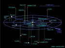
I was thinking of something like this. This is a radius of 12.5 light years.

View attachment 36666

This is one without the trade routes. It covers a slightly bigger region than the sample above - about 33 light years (10 parsecs) on a side. I think something like this combined with a schematic map like the one robertsconley robertsconley did above might be a good compromise between immersion and usability. One could diddle about with the colour scheme, but this is done to be printed on a laser printer without going through buckets of toner.

MapSample3.png
 
Last edited:
I thought that was likely what you did. I like the schematic map from an ease-of-use standpoint, and I think I would supplement the rendered 3D maps with a schematic of the routes.

Building a software visualiser is also possible, but that puts one on the hook for getting it working and keeping it fed and watered across whatever platforms one might want to support - or letting it fade into obsolescence at some point. Heaven and Earth is the example that comes to mind - it's dependent on an obscure 3rd party graphics library and versions of a DLL that aren't around anymore.
The one I use is astrosynthesis by nbos. I had it since Windows 7 and it held up.

The database I used is founded on the Nbos forums and allows you to merge several real world databases into a monster sphere extending out to around 100 light years.

Here is the graphml for Yed I that managed to import. It is in raw format i.e. I didn't try to pretty it up.

 
A 30 parsec jump would be an enormous volume of space with many thousands of stars. Even with the 10 parsec sectors in the examples above I had to cull most of the red dwarf stars to reduce clutter on the maps to manageable levels.
Yea, that was one of the things that got me away from it. Also, because of that distance, through most of a reasonable campaign space, our known star list doesn't have most of the stars, especially main sequence stars. So I was inventing stars. And as I gave it more and more consideration, it seemed unlikely anyone would interested in other than garden worlds. And if we're all on garden worlds, what really is there to trade? The whole thing just fell apart in my mind.
 
The one I use is astrosynthesis by nbos. I had it since Windows 7 and it held up.

The database I used is founded on the Nbos forums and allows you to merge several real world databases into a monster sphere extending out to around 100 light years.

I have mixed feelings about Astrosynthesis. I did get it at one point and it could be useful, in theory at least. However, I don't think it has an option for a free redistributable, so you can't really use it as a vehicle to redistribute to end users for browsing a 3D map. They would still be on the hook for buying it.

QT would allow one to make a portable application and supports major desktop and mobile platforms; I suppose it wouldn't be a major strain to blow the cobwebs out of my C++, and the licence does allow free use for an open-source project if one was to distribute the viewer as such. However, that puts one on the hook for keeping an application fed and watered. OTOH QT has legs and due to its presence in the OSS world (e.g. KDE) it's more likely to last as a platform than some other options. Unity might also be an option, but I don't think there is a free version and the pro version is subscription only and quite expensive.

Another option might be Blend2Web, which is a WebGL exporter for Blender models. Blender is scriptable and one could write something that parsed input files and constructed a model in the platform. This actually feels like the path of least resistance but one would be limited in the features available at runtime.

From my brief survey, WebGL itself isn't too painful to code for - it's Javascript with a GL-ish API for 3D models. A hand-coded WebGL renderer might also be an option, but it still gets you into the treadmill of write-once-test-everywhere and keeping up with the joneses and their latest browser version. It's also dependent on a web server, although it could be implemented as static content with client-side only scripting.

As a baseline I still like a 3D map and a schematic of routes along the lines of the one you did earlier. That would give some immersion in that one could see a star map, and a guide that was easier to read. Really, the software needs to be optional for the end user.
 
Last edited:
A 30 parsec jump would be an enormous volume of space with many thousands of stars. Even with the 10 parsec sectors in the examples above I had to cull most of the red dwarf stars to reduce clutter on the maps to manageable levels.
But here the thing. How many of those worlds would humanity care about? A while back I developed software generators for GURPS Space, Traveller Book 6 Scout, and several other system. The odds of a world being worth exploited for resources or is inhabitable was low for these systems. Even Traveller Book 6 when you do the temperature calculations to resulted in inhabitable worlds being few and far between. Between 150 to 200 worlds per sectors I will lucky to get a dozen worth something.

So unless the campaign is about surveying marginal world after marginal world. Then you can just create 12 to 24 for a large volume of a space and just focus on those when you have something like 30 parsec jumps avaliable.

If you want to see just how bad it is. I recommend buying and downloading Space Engine which uses a pretty solid procedural generation system to explore the universe. It includes real world data in periodic updates. L

 
I have mixed feelings about Astrosynthesis. I did get it at one point and it could be useful, in theory at least. However, I don't think it has an option for a free redistributable, so you can't really use it as a vehicle to redistribute to end users for browsing a 3D map. They would still be on the hook for buying it.
But you can dump images and PDFs from it.

QT would allow one to make a portable application and supports major desktop and mobile platforms; I suppose it wouldn't be a major strain to blow the cobwebs out of my C++, and the licence does allow free use for an open-source project if one was to distribute the viewer as such. However, that puts one on the hook for keeping an application fed and watered. OTOH QT has legs and due to its presence in the OSS world (e.g. KDE) it's more likely to last as a platform than some other options. Unity might also be an option, but I don't think there is a free version and the pro version is subscription only and quite expensive.
There is Celestia which can import data. SpaceEngine is better but $$$.
 
But you can dump images and PDFs from it.


There is Celestia which can import data. SpaceEngine is better but $$$.
From what I can tell Celestia doesn't actually show a star map and to put a star system in you need to supply graphical artifacts such as textures. Space Engine does it procedurally if I recall correctly but I don't recall seeing a mapping function; having said that it's quite a while since I last tinkered with Space Engine.

I did look around at this stuff a while ago and I don't think there's anything out there that actually does this at the right level of abstraction.
 
I forgot Winchell Chung maps uses parsecs. Here is one within 12.5 light years of Earth I made from my own data.

1633979382248.png
 
I forgot Winchell Chung maps uses parsecs. Here is one within 12.5 light years of Earth I made from my own data.

View attachment 36671
Parsecs is also something I've had trouble with in Astrosynthesis. It really doesn't like working in parsecs. It might be fixed now, but a few years ago it went through two or three versions where if you tried to set up a map using parsecs as units it would drop back to light years.
 
But here the thing. How many of those worlds would humanity care about? A while back I developed software generators for GURPS Space, Traveller Book 6 Scout, and several other system. The odds of a world being worth exploited for resources or is inhabitable was low for these systems. Even Traveller Book 6 when you do the temperature calculations to resulted in inhabitable worlds being few and far between. Between 150 to 200 worlds per sectors I will lucky to get a dozen worth something.

So unless the campaign is about surveying marginal world after marginal world. Then you can just create 12 to 24 for a large volume of a space and just focus on those when you have something like 30 parsec jumps avaliable.

If you want to see just how bad it is. I recommend buying and downloading Space Engine which uses a pretty solid procedural generation system to explore the universe. It includes real world data in periodic updates. L


One of the problems I had was that once you get to a jump over a certain distance, the number of routes between X and Y becomes so large that it's meaningless to set up any sort of defensive perimeter. In fact, you could in theory have two overlaid polities (maybe slightly different preferences for "garden" world) that share no or almost no stars. So part of my decision to go back to Classic Traveller and 2-D maps is that positioning on the map actually matters.
 
But you can dump images and PDFs from it.

Gettng static pictures isn't the problem - the renderer for the stuff I've been posting here didn't take all that long to write. SVG also has a similar imaging model to PostScript so one could build something web based in much the same way.

What I'm really talking about is an interactive, redistributable 3D visualiser that lets a user view the map from different angles or pan through it. The main feature here is an interactive map viewer; pretty rendered pictures of individual planets are really a nice to have for this application. One could certainly build such a thing, but I think that keeping it fed and watered on multiple platforms is a bigger commitment that one might really want to get into, and I don't think any of the existing applications really offer a solution for doing quite what I described. Blend2Web seems the closest.

At the moment building something like that feels a bridge to far.
 
Last edited:
Why do you need lines between all the stars? Why not just put a legend with a light year measurement and then use some lines for major trade routes. They probably won’t be all straight either.
 
Why do you need lines between all the stars? Why not just put a legend with a light year measurement and then use some lines for major trade routes. They probably won’t be all straight either.
Yup, in my opinion the maps need to be cleaner and clearer. Easier to read in other words. Often the maps are soo damn busy as to make your eyes glaze over. Keep it as simple as possible in layout. A lot of these maps remind me of the worst aspects of many who post on the GURPS forums and Reddit these days. They get so far in the weeds that they couldn't find their own asses with two hands.

Don't misunderstand me, I do prefer crunchier game systems and detailed maps, but there is a point where it becomes an unreadable mess that makes most viewers eyes glaze over. That's a problem.
 
Two things. #1 theres a lot more going on in that Graphviz drawing which makes it look much busier and takes up more space than in the yEd pic. #2 I believe you can tweak Graphviz to look more like the yEd output if you want.
I like how busy it is, but none the less streamlined and organized. Conveys a real technical feel, like it might be something of a real future ship manual.
 
These star maps all seem too cluttered. I want high signal to noise either as a player or GM. What's got a coloizable planet, mining colony, ancient ruins
 
Banner: The best cosmic horror & Cthulhu Mythos @ DriveThruRPG.com
Back
Top