Help me with this D&D region map I'm making?

Best Selling RPGs - Available Now @ DriveThruRPG.com

Shipyard Locked

How long do I have?
Joined
Apr 25, 2017
Messages
2,671
Reaction score
5,718
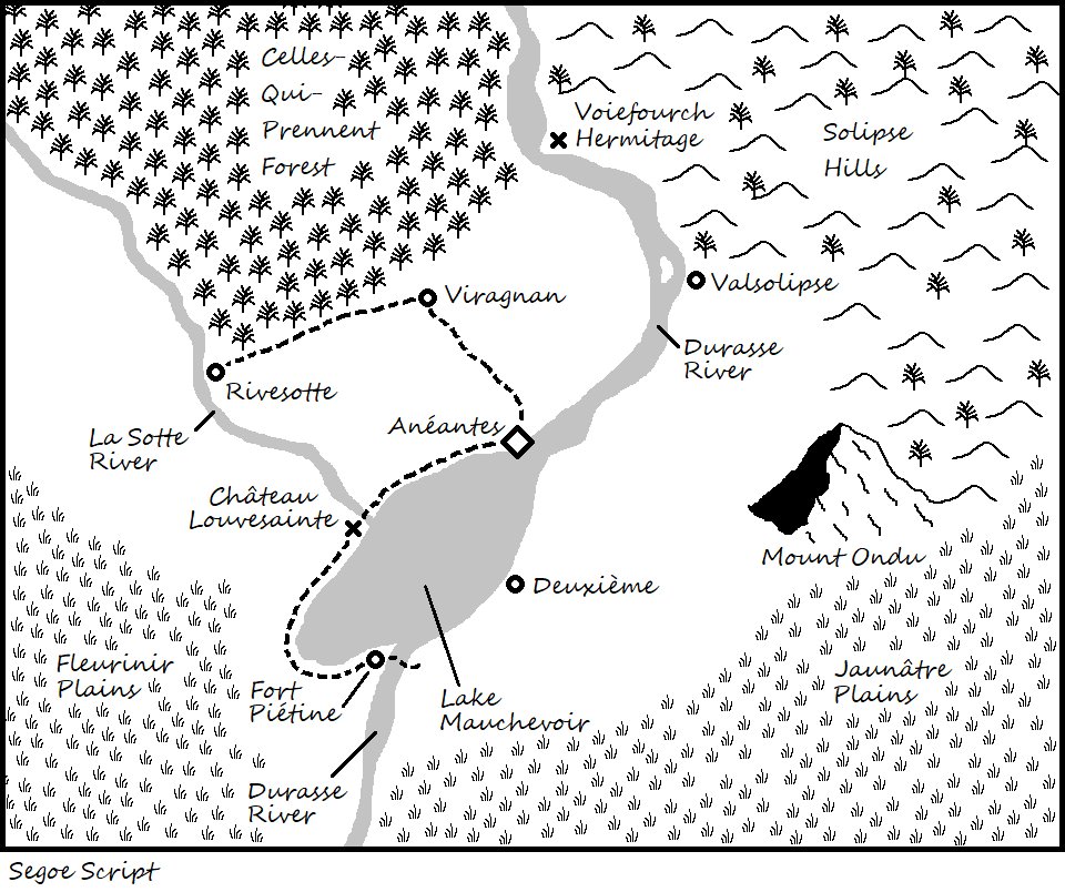
Hey folks, working on a D&D region map for a mystery-focused Ravenloft campaign. I could use some advice and critique.

A few notes first:
- I'm not using hexes for this one, I'm going for a looser investigation/sandbox vibe instead. Certain parts of the map will get "zoom in" versions later for me to run behind the screen.
- The diamond is the city. The circles are towns. Xs are miscellaneous locations. Dashed lines are roads.
- I'm undecided on whether to have the tech level here be French medieval or French renaissance with a veneer of Napoleonic. Whatever I go with, cavalry must be important.
- Despite being a region for a Gothic horror campaign, I want it to feel very pleasant and safe. The horror is more insidious.
- My plans assume there is an "enemy" state nearby, off the edge of the map, probably to the south-east, but see below.
- The rivers flow north to south.
- Because this is a Ravenloft domain, there is nothing but mist beyond the edges of the map. The locals are supernaturally deluded into believing a normal world still exists out there. Trade still comes down the river, but the merchants are mysterious and creepy, so locals avoid thinking about them too much.

OK, now for some questions I have:
- Where would forts or other such defensive structures realistically be placed in this environment? The chateau is up on a cliff and includes a bridge over the river.
- Is there anything obviously unrealistic going on here, aside from this being a cursed domain cut off from reality?
- What scale would you make this? How many miles per inch?
- What would you do with those spaces in the center right and left?
- Do the names feel right?

Thanks for any advice you can share.

ajFGlV4.png
 
Good rule of thumb is imagine needed goods, their exchange, and the easiest shipping between. Where people can ship TONS by water, there has to be a good reason that they do not take advantage of the nodes where a water course changes. Where people can do agriculture with eased irrigation, there has to be a good reason that they do not take advantage of fertile floodplain flatlands.

This is either really small, and thus one city surrounded by villages and hamlets everywhere water can fertilize crops, or this is enormous and the road is (for the most part redundant) major works project. Either way the South in general is under populated -- unless it is enormous like the Great Plains of the USA or Central Asia -- and the South East (by the Jaunâtre Plains) especially. If it is barely a county, then yes, this is fine, but cavalry will play a far smaller role. If this is larger than a county, each river connection to the lake should have a village attached just for lade point transfers alone. If this is enormous, like central USA states, then it could work as that barren.

If this is to be infantry/archer defensible, either Valsolipse or Rivesotte would be defensible terrain for infantry/pike/archer peasant levies. But honestly the best bet with that many plains would be a horse culture centered on a city straddling the Southern Durasse River -- with access to plains on either side for rapid deployment (likely having a separate cavalry for each side). The North-to-South flow alone makes that lower Durasse a lynchpin point for further trade, and thus starving out any insurrection in the forest or hills. Cavalry siege harassment tactics, and the lower Durasse city-navy, would wear down any Northern entrenchment rebellion; no need to hold difficult terrain when their traders will be desperate for Southern grain and trade outwards.

This strong horse culture would also explain an overall safety (their war mobility secures control, as Northern goods feed into its military machine), and why they see threat from the plains further SE.

You need a lot more Southern points of interest. I know, it's hard because they are plains. Throw on a few famous battlefields and a seasonal cattle or horse round up area?
 
Last edited:
Quick answers, more later:
- I'll put a city on the bottom river. Or should I just move Aneantes? Or could I simply put a cavalry fort there, supplied by the communities above it?
- The intent is for this to feel like part of a much bigger empire (which isn't there anymore because Ravenloft) so I do imagine it to be on the smaller side.
- The road to the chateau is an extravagance, but I like the look and feel of it.
- This map is intended to be player visible, so a lot of the points of interest in the plains will be hidden. That is, unless there really should be certain big visible landmarks out there that I'm overlooking. Probably some standing stones, a ruined town of some sort.
 
Where would forts or other such defensive structures realistically be placed in this environment?
What are they defending against? Given what you've said about the place, it doesn't sound like they would often be attacked by traditional armies.
What scale would you make this? How many miles per inch?
I would base that mainly on what kinds of travel times make sense for your campaign. Given that this is Ravenloft, I'm guessing things get a lot more dangerous at night. In that case, you might want to space settlements so each is within one day of at least one other.
What would you do with those spaces in the center right and left?
Some of that terrain can be farmlands, but probably only within an hour or two of each settlement. It looks like you've left the terrain undecided. You should definitely have some swamps and marshes near the lake. But away from it, I'd just make it mostly forest. I took a quick look at wikipedia, and it seems to suggest that plains form mostly at the foot of mountains, and I don't see any on this map. They could be off-map in theory, but you've indicated that it's a wall of mist at the edge of the map, so that doesn't really make sense. You might want to put some mountains somewhere so you can have some nice valleys, but otherwise, I'd go mostly with forest. In a Ravenloft-type of setting, you're not going to see as much cultivated or cleared land as in our world's medieval era.
 
The wikipedia page on plains has some interesting information that might help:
Types of plain

A small, incised alluvial plain from Red Rock Canyon State Park (California).​

A flood plain in the Isle of Wight.​
Depositional plains
Depositional plains formed by the deposition of materials brought by various agents of transportation such as glaciers, rivers, waves, and wind. Their fertility and economic relevance depend greatly on the types of sediments that are laid down.[6] The types of depositional plains include:
  • Abyssal plains, flat or very gently sloping areas of the deep ocean basin.[7]
  • Planitia, the Latin word for plain, is used in the naming of plains on extraterrestrial objects (planets and moons), such as Hellas Planitia on Mars or Sedna Planitia on Venus.
  • Alluvial plains, which are formed by rivers and which may be one of these overlapping types:
    • Alluvial plains, formed over a long period of time by a river depositing sediment on their flood plains or beds, which become alluvial soil. The difference between a flood plain and an alluvial plain is: a flood plain represents areas experiencing flooding fairly regularly in the present or recently, whereas an alluvial plain includes areas where a flood plain is now and used to be, or areas which only experience flooding a few times a century.[8]
    • Flood plain, adjacent to a lake, river, stream, or wetland that experiences occasional or periodic flooding.
    • Scroll plain, a plain through which a river meanders with a very low gradient.
  • Glacial plains, formed by the movement of glaciers under the force of gravity:
    • Outwash plain (also known as sandur; plural sandar), a glacial out-wash plain formed of sediments deposited by melt-water at the terminus of a glacier. Sandar consist mainly of stratified (layered and sorted) gravel and sand.[9][10]
    • Till plains, plain of glacial till that form when a sheet of ice becomes detached from the main body of a glacier and melts in place depositing the sediments it carries. Till plains are composed of unsorted material (till) of all sizes.
  • Lacustrine plains, plains that originally formed in a lacustrine environment, that is, as the bed of a lake.[11]
  • Lava plains, formed by sheets of flowing lava.[12]
Erosional plains
Erosional plains have been leveled by various agents of denudation such as running water, rivers, wind and glacier which wear out the rugged surface and smoothens them. Plain resulting from the action of these agents of denudation are called peneplains (almost plain) while plains formed from wind action are called pediplains.[13]

Structural plains
Structural plains are relatively undisturbed horizontal surfaces of the Earth. They are structurally depressed areas of the world that make up some of the most extensive natural lowlands on the Earth's surface.[14]
 
What are they defending against? Given what you've said about the place, it doesn't sound like they would often be attacked by traditional armies.

The trick is that they don't know their traditional enemies aren't out there anymore. Their minds are addled by the curse on the land, so they continue to prepare for attacks that never come.

I would base that mainly on what kinds of travel times make sense for your campaign. Given that this is Ravenloft, I'm guessing things get a lot more dangerous at night. In that case, you might want to space settlements so each is within one day of at least one other.

Yes, nighttime is the highest danger level. I guess I want this space to be a sandbox with a mystery-solving focus, so I need just enough space for the exploration to last many sessions but not so vast that I need to create more high-profile settlements to be realistic. I'm also assuming there are tiny, unmarked hamlets and manors dotted everywhere that don't need to be put on an overview map.

Some of that terrain can be farmlands, but probably only within an hour or two of each settlement. It looks like you've left the terrain undecided.

I'm currently treating the blank, "untextured" areas as farmland (obviously the map is an unfinished draft).

They could be off-map in theory, but you've indicated that it's a wall of mist at the edge of the map, so that doesn't really make sense.

It doesn't make sense anymore, but before the land was dragged into the demiplane they would have been there.

You might want to put some mountains somewhere so you can have some nice valleys, but otherwise, I'd go mostly with forest. In a Ravenloft-type of setting, you're not going to see as much cultivated or cleared land as in our world's medieval era.

Good point. I guess it also depends on if I'm going for medieval or Renaissance/Napoleonic. I'll have to make that decision soon.
 
I would put a fort with a bridge on the pennisula on the west side of where othe Durasse River enters Lake Mauchevior. It is protected by the river from the enemy to the SE and the bridge allows the forces to sally into the Jaunaire Plains. If a enemy moves towards Valsolipse or Deuxieme the forces can easily sweep behind them.

Likely they will have a ford mapped up river to cross over with in case a enemy force encamps across the river and they have to destroy the bridge.

Continue the road to the fort and you will have a reason for it existing.
 
Sounds like this is county-to-duchy level topography (To use "Crusader Kings" sizes). :smile:

I like moving Anéantes to the south Durasse river peninsula. But I also like robertsconley's fort idea for the same location. :quiet: 
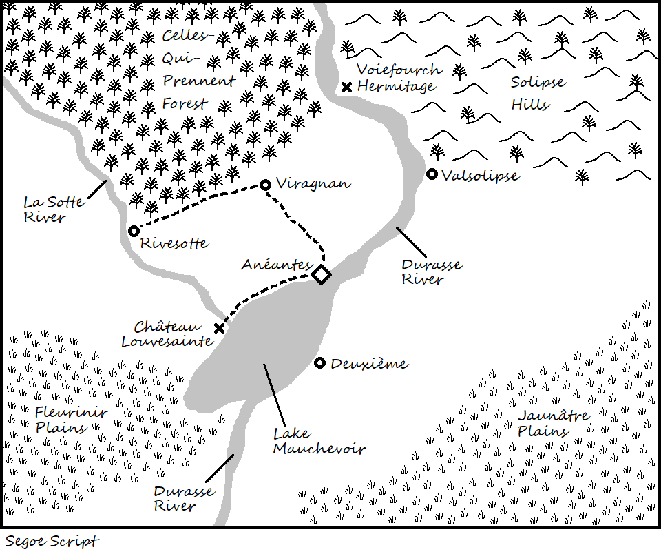
I say split the difference and have the Peninsular Fort be the new capital boom town, and Antéantes the ancient regime county seat. :wink: Put the noble palisades and overgrown fort on the West of the river (with a new garrisoned fort on the East), the breeding stables on both the West and East side, and the trading post on the East.

Then you can mix old vs. new splendor: bucolic old lake capital vs. bustling caravan fort capital. It also throws in reason for "threatening border empire" trade, which will build on the cultural exchange contrast. It also gives Vistani reason to travel to, about, and through the domain.
 
Thanks for all the great ideas folks!

Working on the new map, but it'll take a day or two. Coming up with names is hard and I'm busy at work again.

Oh, and drawing a mountain in MS paint is tricky!
 
Oh, and drawing a mountain in MS paint is tricky!
Wow, yeah. You made that in Paint? That's a really nice map in that case, but I can't help thinking that there are easier ways. I'm working on a couple of different maps and I've been using Hex Kit. Except for how it does roads and rivers (always insists on connecting at corners instead of mid-side), I'm super happy with it. But since you don't want to do hexes I'm not sure what is best. Dungeon Painter Studio is decent at many facets of mapping without excelling at anything in particular.
 
Alright, new version, but still tweaking...

U6dck2N.png


Some comments/questions:
- I've added Fort Pietine on the peninsula and it's creeping up into new large town status as Opa suggested, but I don't think I want it to be a rival to Aneantes yet. I definitely like it as a place to launch patrol into either plains.
- I've added a solitary mountain, pretty in the daylight and brooding at night. I'm not sure how realistic its placement is. Thoughts?
- Should I still put something in that space between Valsolipse and Deuxieme, or is the mountain enough? I'm not sure swamps are part of my visual for this place.
- I cleared some space on the right side of the map by moving the river name. Not sure what I should put there though. Maybe something similar to a "dungeon" but large and open-air so PCs could still ride horses through it, Fire Emblem style?
 
I've added a solitary mountain, pretty in the daylight and brooding at night. I'm not sure how realistic its placement is. Thoughts?
It's on the edge of the hills, so it doesn't seem that bad. And I kind of like it either way - the idea of a lone mystery mountain has a nice romantic feeling that goes with your setting.
 
Turn that mountain into an eroded volcano plug, like Devils Tower! :heart:

devils_tower_in_autumn__wyoming.jpg
 
Hmm, part of me likes the Devil's Tower idea, but another part of me hesitates because it is so strongly associated with Close Encounter of the Third Kind and could be distracting. I'll have to think about it.
 
Banner: The best cosmic horror & Cthulhu Mythos @ DriveThruRPG.com
Back
Top